
1
LOUISIANA DEPARTMENT OF
WILDLIFE & FISHERIES
OFFICE OF FISHERIES
INLAND FISHERIES SECTION
PART VI -A
WATERBODY MANAGEMENT PLAN SERIES
LARTO-SALINE COMPLEX
LAKE HISTORY & MANAGEMENT ISSUES
2
CHRONOLOGY
June 2014 - Prepared by
Richard D Moses, Biologist Manager, District 3
Richard McGuffee, Biologist Supervisor, District 3
Shelby Richard, Biologist II, District 3
March 2018 – Revised by
Richard McGuffee, Biologist Manager, District 3
Shelby Richard, Biologist Supervisor, District 3
January 2021 – Revised by
Richard McGuffee, Biologist Manager, District 3
Shelby Richard, Biologist Supervisor, District 3
Hannah Burnett, Biologist II, District 3
The remainder of this page left intentionally blank.
3
TABLE OF CONTENTS
LAKE HISTORY ........................................................................................................................................................ 5
GENERAL INFORMATION .......................................................................................................................................... 5
Date Reservoir Formed ......................................................................................................................................... 5
Impoundment ......................................................................................................................................................... 5
Size ......................................................................................................................................................................... 5
Watershed .............................................................................................................................................................. 5
Pool Stage .............................................................................................................................................................. 5
Location ................................................................................................................................................................. 5
Drawdown Description .......................................................................................................................................... 5
Spillway ................................................................................................................................................................. 5
Description of the Dam .......................................................................................................................................... 6
Outlet Works (Drawdown Structure) ..................................................................................................................... 6
Structure Control ................................................................................................................................................... 6
LAKE AUTHORITY..................................................................................................................................................... 6
ACCESS ...................................................................................................................................................................... 7
Boat Launches ....................................................................................................................................................... 7
Piers ....................................................................................................................................................................... 7
State/Federal Facilities ......................................................................................................................................... 7
Reefs ...................................................................................................................................................................... 7
SHORELINE DEVELOPMENT ..................................................................................................................................... 7
State/National Parks .............................................................................................................................................. 7
Shoreline Development by Landowners................................................................................................................. 7
PHYSICAL DESCRIPTION OF LAKE ........................................................................................................................... 8
Shoreline Length .................................................................................................................................................... 8
Timber Type ........................................................................................................................................................... 8
Average Depth ....................................................................................................................................................... 8
Maximum Depth .................................................................................................................................................... 8
Natural Seasonal Water Fluctuation ..................................................................................................................... 8
EVENTS / PROBLEMS ................................................................................................................................................. 8
MANAGEMENT ISSUES .......................................................................................................................................... 9
AQUATIC VEGETATION............................................................................................................................................. 9
Type Map ............................................................................................................................................................. 10
Biomass ................................................................................................................................................................ 10
Biological Control ............................................................................................................................................... 10
Chemical Control ................................................................................................................................................ 10
HISTORY OF REGULATIONS .................................................................................................................................... 13
Recreational......................................................................................................................................................... 13
Commercial ......................................................................................................................................................... 13
DRAWDOWN HISTORY ............................................................................................................................................ 14
Fishing Closure ................................................................................................................................................... 14
Depth Below Pool ................................................................................................................................................ 14
Estimated Percent Exposed ................................................................................................................................. 14
Structure Operation ............................................................................................................................................. 15
Fish Kills ............................................................................................................................................................. 15
CONTAMINANTS / POLLUTION ................................................................................................................................ 15
Water level ........................................................................................................................................................... 15
BIOLOGICAL ............................................................................................................................................................ 15
Fish Samples ........................................................................................................................................................ 15
Lake Records ....................................................................................................................................................... 16
4
Stocking History .................................................................................................................................................. 16
Genetics ............................................................................................................................................................... 17
Species Profile ..................................................................................................................................................... 17
Threatened/Endangered/Exotic Species .............................................................................................................. 20
Creel Survey ........................................................................................................................................................ 21
Fish Kills, Disease History, LMBV ...................................................................................................................... 21
HYDROLOGICAL CHANGES..................................................................................................................................... 21
WATER USE ............................................................................................................................................................. 21
Hunting ................................................................................................................................................................ 21
Recreational Watersports .................................................................................................................................... 21
Fishing ................................................................................................................................................................. 21
Scuba Diving........................................................................................................................................................ 22
Swimming ............................................................................................................................................................ 22
Irrigation ............................................................................................................................................................. 22
APPENDIX I .............................................................................................................................................................. 23
APPENDIX II ............................................................................................................................................................ 25
APPENDIX III ........................................................................................................................................................... 30

5
LAKE HISTORY
General Information
The Larto-Saline Complex is a large natural backwater complex located in east-central
Louisiana. Portions of the complex are located in Catahoula, LaSalle, Avoyelles and Rapides
Parishes. The Complex includes Larto Lake, Saline Lake, Shad Lake, and numerous
interconnecting bayous and smaller lakes. The complex receives regular backwater flooding
from Red River, Black River, and Little River. In any given year, the dominant source of
flooding, as well as the extent and duration of flooding, can influence fisheries production
and aquatic weed growth. Maps of the complex are found in Appendix I.
Date Reservoir Formed
Historically, Larto-Saline Complex was a natural body of water. In 1959, the Larto Lake Dam
was designed by the Louisiana Department of Public Works and constructed by J.A. Harper
Construction Company. It was designed to maintain a water level of 36.0’ Mean Sea Level
(MSL). In 1969, the spillway crest height of the Larto structure was raised to 37.0’ MSL.
Impoundment
This natural body of water was impounded in 1959 to maintain water levels during dry periods.
Size
Larto Lake, Saline Lake, Shad Lake, and numerous smaller lakes and bayous interconnect for
a combined surface area of approximately 8,200 acres.
Watershed
Approximately 90,880 acres or 142 sq. miles (watershed ratio 11:1)
Pool Stage
37.0 feet Mean Sea Level (MSL)
Location
Catahoula, LaSalle, Avoyelles, and Rapides Parishes
Drawdown Description
The lake water level can be lowered approximately one inch per day. There is only one
drawdown gate. The lake can be dewatered approximately 6 feet to a level of 31 feet MSL.
Spillway
The spillway is 257-feet wide and consists of four flapper gates that are approximately 4
feet high by 7 feet wide.

6
Description of the Dam
Larto Lake Dam consists of 2,930 feet of earthen embankment, including a 257-foot-wide
spillway on the southwest end of Larto Lake. The paved surface of LA 3102 is located on
top of the earthen embankment.
Dam height is 38 feet.
Structural height is 38 feet.
Hydraulic height is 35 feet.
Maximum discharge is 4,407 cubic feet per second
Maximum storage is 126,000 acre-feet.
Normal storage is 15,000 acre-feet.
Surface area is 8,200 acres.
Drainage area is 142 square miles.
Outlet Works (Drawdown Structure)
The outlet works (drawdown gate) consists of a single 9 ft. wide x 11 ft. high gate located in
the vertical face of the concrete spillway wall. The gate is operated by turning a gearbox with
an electric drill to open or close the gate.
Structure Control
Per the Louisiana Department of Transportation and Development (LADOTD) dam
inspection and evaluation report dated August 10, 2010, the operation and maintenance
are the responsibility of the owner, the State of Louisiana. The gate is operated by the
Louisiana Department of Transportation at the request of the Louisiana Department of
Wildlife and Fisheries.
Lake Authority
The Larto Lake Commission was abolished on September 13, 2004 by the Catahoula Parish Police
Jury. The Catahoula Parish Police Jury (CPPJ) is considered as the lake authority for Larto
Lake.
Primary contact information- Catahoula Parish Police Jury
P.O. Box 258
Harrisonburg, LA. 71340
Tel: 318-744-5435

7
Access
Map with access locations in Appendix I.
Boat Launches
Table 1. Boat launches found on Larto-Saline Lake Complex, Louisiana.
Ramp Name
Coordinates
Ramp
Parking
Youngblood’s
31.361909° -91.949958°
Concrete
Dirt – 25 trailers
Saline Bayou Camp Area
31.347523° -91.990739°
Concrete
Dirt – 25 trailers
Muddy Bayou Camp Area
31.390479° -92.048831°
Concrete
Dirt – 25 trailers
Big Creek-HWY 115
31.302470° -92.152303°
Concrete
Gravel – 10 trailers
Sanders
31.373413° -91.905009°
Concrete
Gravel – 20 trailers
Larto Lodge
31.377167° -91.911167°
Concrete
Gravel – 20 trailers
Uncle Buds
31.378041° -91.920924°
Concrete
Gravel - 20 trailers
Woodson’s
31.305234° -92.141075°
Concrete
Gravel – 25 trailers
Open Bayou
31.341057° -92.096857°
Concrete
Gravel – 50 trailers
Phil’s
31.391866° -92.006900°
Concrete
Gravel – 25 trailers
Piers
There are no public fishing piers located in the Larto-Saline Complex; however, numerous
private piers are located on the lakes. The majority of the private piers are located on the east
side of Larto Lake.
State/Federal Facilities
Dewey Wills Wildlife Management Area (WMA), owned and managed by LDWF, is located
along the majority of the shoreline. This WMA consists of 60,000 acres of bottomland
hardwood forest. It is open to the public for hunting, fishing, camping, and outdoor recreation.
Reefs
There are no LDWF constructed artificial reefs in this lake. However, there are numerous
structures placed by fishing guides and anglers to attract fish.
Shoreline Development
State/National Parks
No state or federal parks are located on Larto-Saline.
Shoreline Development by Landowners
Overall, the majority of the shoreline is not developed. The portion of the shoreline within the
Dewey Wills WMA is undeveloped bottomland hardwood forest. The areas of shoreline that

8
are privately owned are developed extensively. The southeastern shoreline of Larto Lake is
privately owned and developed extensively with houses, camps, and private piers.
Approximately 60% of the shoreline is developed around Larto Lake. There are also some
private land inholdings in the Cross Bayou, Muddy Bayou, and Big Saline Bayou areas that
are developed with camps.
Physical Description of Lake
Shoreline Length
175 miles
Timber Type
The majority of the lake is not timbered. Bald Cypress (Taxodium distichum), scattered
Buttonbush (Cephalanthus occidentalis) and Swamp Privet (Forestiera acuminate) occur
along the lakes and bayous.
Average Depth
8 Feet
Maximum Depth
18 feet
Natural Seasonal Water Fluctuation
The Larto-Saline Complex receives regular backwater flooding from Red River, Black River,
and Little River. In any given year, the dominant source of flooding, as well as the extent and
duration of flooding, can influence fisheries production and aquatic vegetation growth. During
extreme flood years, annual water level fluctuation can exceed 10 feet. Fluctuations of 3-5 feet
are more typical.
Events / Problems
Turbidity became a problem in the early 1970’s following the U.S. Army Corp. of Engineers
(USACE) Ouachita-Black Rivers Navigation Project. Due to the project design, additional
construction of the Diversion Canal and Archie Structure on Little River was required in order
to manage water levels on Catahoula Lake to mitigate impacts to waterfowl habitat. By 1970,
the connection between Larto Lake and Black River via Island Bayou and Honey Brake was
closed by levees created during the construction of the Catahoula Lake Diversion Canal.
In 1979, the USACE released a draft of the “Larto Lake, Saline Lake, Louisiana
Reconnaissance Report”. This report addressed water quality and fisheries problems in the
Larto-Saline Complex and acknowledged that Red River backwater was the primary source of
sediments causing turbidity problems. Red River became the primary source of backwater due
to the spoil bank that was created during the construction of the Catahoula Lake diversion

9
canal. This spoil bank blocked inflow of floodwater from other sources, primarily Black River
and Little River.
This problem was resolved after the construction of a weir between Cross Bayou and the
diversion canal. The Cross Bayou Weir (CBW) was completed and operational in 1987. Water
quality and fisheries improved significantly. This structure allowed the less turbid waters of
the Ouachita River to enter the lake complex over the Cross Bayou weir. The CBW elevation
was set at 37.0 MSL, which allowed for higher clarity flood waters to enter the system before
the turbid Red River water entered the system. The installation of the flap gates on the Larto
Lake structure prevents water from entering the system until the Red River water level exceeds
42.0 MSL.
The construction of the Catahoula Lake diversion canal also created another problem, an ideal
situation for erosion. Erosion breaches between the lake complex and the diversion canal have
been reoccurring and problematic. Breaches have occurred mainly in three areas: Denny’s
Drain, Open Mouth Bayou, and at the Cross Bayou Weir. This typically occurs after high water
events as the water begins to recede. The most recent event was a breach in the Cross Bayou
Weir in January 2013. The weir was repaired in 2014. New sheet piling was driven and more
rock was added.
A comprehensive history of the Larto-Saline Complex can be found in Appendix II.
MANAGEMENT ISSUES
Aquatic Vegetation
Aquatic vegetation species composition and coverage is dependent on the frequency and
duration of backwater flooding in the system. Prior to the construction of the Cross
Bayou Weir in 1987, turbidity limited the growth of submersed vegetation. Historically,
after several of years without high water events, submersed vegetation, primarily
Hydrilla (Hydrilla verticillata), would become problematic in the complex. American
Lotus (Nelumbo lutea) and Water Hyacinth (Eichhornia crassipes) occur in shallow
water areas of the complex and are sometimes problematic in late summer. Common
Salvinia (Salvinia minima) is found in the complex, and can become problematic in
backwater areas of the lakes. Giant Salvinia (Salvinia molesta) was discovered in the
complex in October 2012 at the Open Bayou boat ramp. An intense survey of the
immediate area was conducted and no additional Giant Salvinia was located.
Department spray crews treated the area repeatedly over the next few months to prevent
the Giant Salvinia from spreading. In October of 2016, Giant Salvinia was discovered
again in the Open Bayou/ Little Saline area. Since the discovery, a high water event
flushed the salvinia out and spread the vegetation into the coves and bayous connected
to Saline Lake. High water events that lasted into the summer months occurred in 2018

10
and 2019. These events allowed Giant Salvinia to spread throughout the rest of the
complex and into many of the sloughs, lakes, bayous, and backwater areas not
permanently connected to the main water body.
A vegetation survey was conducted on June 25, 2020. No submersed vegetation was
observed. Emergent vegetation consisted of Alligator Weed (Alternanthera
philoxeroides) and Water Primrose (Ludwigia peploides). There were approximately
100 acres combined. No water lotus was observed, even though it is typically present.
The absence of submersed vegetation and American lotus is likely due to the
consecutive and prolonged high waters in the past few years. Floating vegetation
consisted of Giant Salvinia, Common Salvinia, and Water hyacinth. There were
approximately 800 acres of Giant Salvinia present. This was located in the Shad Lake
area and the backs of the many bayous and coves in the complex. There were
approximately 200 acres of Common Salvinia present, mainly located in the Shad Lake
area. There were approximately 100 acres of water hyacinth present.
Vegetation projections in 2021 will depend on water levels and freezing weather events.
Submersed vegetation and American Lotus will likely return if no prolonged high water
events occur. Salvinia will likely increase, although the lake drawdown of 2020 and the
freeze event that occurred in February 2021 has reduced the total coverage in the lake.
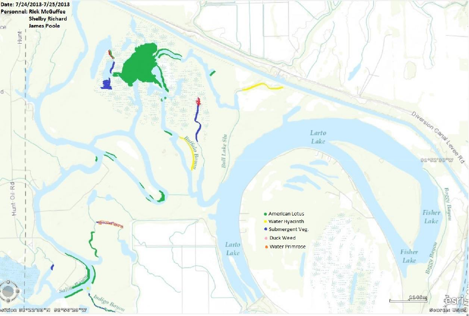
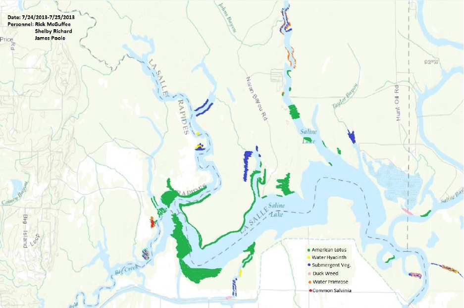
Type Map
Vegetation surveys (type maps) are conducted periodically on the Larto-Saline
Complex. Annual vegetation coverage is variable; following years of backwater
flooding, vegetation is minimal. Vegetation type map surveys were conducted on the
Larto/Saline Complex in 2006, 2007, 2013, and 2021. Vegetation survey maps can be
viewed in Appendix III.
Biomass
No vegetation biomass sampling has been conducted.
Biological Control
Salvinia Weevils (Cyrtobagous salviniae) have been stocked yearly since 2017 in an attempt
to establish a population of weevils that will help control the growth of Giant Salvinia.
Populations will be monitored each year to determine the success of the stocking. The
number stocked each year is as follows:
2017: 62,670 Giant Salvinia Weevils were stocked in various locations around Saline
Lake, Big Creek, and Little Saline Bayou.
2018: 6,750 weevils were stocked. Low numbers stocked due to high water.
2019: 61,233 weevils were stocked in Muddy Bayou.
2020: 144,215 weevils were stocked in various locations of the complex.
Chemical Control
Foliar herbicide applications have been conducted to maintain boating access. Prior to the

11
introduction of Giant Salvinia in 2016, the amount of herbicide sprayed each year was
relatively minor. For a complete summary of herbicide applications see Table 2. Herbicide
types and rates are found in Table 3.
Table 2. Herbicide applications on Larto-Saline Complex Louisiana.
Year
Acres
Vegetation
2005
70
Water Hyacinth
88
Giant Cutgrass
2006
75
Water Hyacinth
2008
94
American Lotus
65
Water Hyacinth
29
Common salvinia
2009
90
Common salvinia
31
Alligator Weed
61
Water Hyacinth
2010
63
Alligator Weed
9
American Lotus
49
Common salvinia
6
Hydrilla
2012
110
Alligator Weed
158
American Lotus
33
Pennywort
57
Primrose
523
Common salvinia
31
Giant salvinia
750
Water Hyacinth
2013
51
Alligator Weed
47
American Lotus
177
Common salvinia
38
Giant salvinia
249
Water Hyacinth
2014
268
Water Hyacinth
2015
34
Alligator Weed
11
American Lotus
56
Common salvinia
81
Water Hyacinth
2016
57
Alligator Weed
277
Common salvinia
370
Giant salvinia
17
Water Hyacinth
2017
509.2
American Lotus
5
Common salvinia

12
1528.6
Giant salvinia
194.7
Water Hyacinth
2018
16.6
Alligator Weed
10
Buttonbush
4
Common salvinia
370.3
Giant salvinia
13.10
Water Hyacinth
2019
8
Common salvinia
174
Giant salvinia
2020
1.6
Button Bush
10.5
Common salvinia
674.8
Giant salvinia
19.6
Water Hyacinth

13
Table 3. LDWF recommended herbicide types and rates.
Plant Species
Herbicide
Surfactant
Salvinia spp. Alternative 1
Common/Giant salvinia
(April 1 to October 31)
Glyphosate (0.75 gal/acre)
Diquat (0.25 gal/acre)
Turbulence (or approved equivalent,
0.25 gal/acre)
Salvinia spp. Alternative 2
Common/Giant salvinia
(April 1 to October 31)
Glyphosate (0.75 gal/acre)
Flumioxazin (2 oz./acre)
Turbulence (or approved equivalent,
0.25 gal/acre)
Salvinia spp. Alternative 3
Common/Giant salvinia
(April 1 to October 31)
MSM (1 oz./acre)
Flumioxazin (1 oz./acre)
Turbulence (or approved equivalent,
0.25 gal/acre)
Salvinia spp. Alternative 4
Common/Giant salvinia
(November 1 to March 31)
Diquat (0.75 gal/acre)
Nonionic surfactant (0.25 gal/acre)
Salvinia spp. Alternative 5
Common/Giant salvinia
(November 1 to March 31)
Flumioxazin (12 oz./acre)
Turbulence (or approved equivalent,
0.25 gal/acre)
Water Hyacinth
2, 4-D (0.5 gal/acre)
Nonionic surfactant (1 pint/acre)
Water Hyacinth in waiver areas
(March 15 to September 15)
Glyphosate (0.75 gal/acre)
Nonionic surfactant (0.25 gal/acre)
Alligator Weed/Giant Cut Grass
(undeveloped areas)
Imazapyr (0.5 gal/acre)
Turbulence (or approved equivalent,
0.25 gal/acre)
Alligator Weed/Giant Cut Grass
(developed areas)
Imazamox (0.5 gal/acre)
Turbulence (or approved equivalent,
0.25 gal/acre)
American Lotus
2, 4-D (0.5 gal/acre)
Nonionic surfactant (1 pint/acre)
American Lotus in waiver areas
(March 15 to September 15)
Glyphosate (0.5 gal/acre)
Nonionic surfactant (0.25 gal/acre)
American Lotus in waiver areas
with potable water intakes
(March 15 to September 15)
Triclopyr (0.5gal/acre)
Turbulence (or approved equivalent,
0.25 gal/acre)
Duckweed
Diquat (1.0 gal/acre) or
Flumioxazin (8 oz./acre)
Nonionic surfactant (0.25 gal/acre) or
Turbulence (or approved equivalent,
0.25 gal/acre)
Cuban Bulrush (sedge)
2, 4-D (0.5 gal/acre)
Nonionic surfactant (1 pint/acre)
Cuban Bulrush (sedge) in waiver areas
(March 15 to September 15)
Glyphosate (0.75 gal/acre)
Nonionic surfactant (0.25 gal/acre)
Water Lettuce
Diquat (1.0 gal/acre) or
Flumioxazin (6 oz./acre)
Nonionic surfactant (0.25 gal/acre) or
Turbulence (or approved equivalent,
0.25 gal/acre)
History of Regulations
Recreational
The recreational fishing regulations may be viewed at the link below:
http://www.wlf.louisiana.gov/regulations
Commercial
The commercial fishing regulations may be viewed at the link below:
http://www.wlf.louisiana.gov/regulations

14
Drawdown History
Drawdowns have occurred on numerous occasions since 1982. Intentional drawdowns were
conducted in 1982, 1983, 1984, 1985, and 1986 to dry and stabilize sediments and reduce
turbidity. These drawdowns reduced turbidity and provided short-term benefits. However,
spring-time high water periods would cause turbid Red River water to flow into the complex.
Unintentional drawdowns have occurred numerous times throughout the history of this
waterbody. In 2008 and 2013, the Cross Bayou Weir and other areas washed out during
periods of extreme high water. This allowed the Larto-Saline Complex water level to fall
below pool elevation. In 2014, the complex was drawn down for Cross Bayou Weir repairs.
A drawdown was conducted in 2020 for the reduction of Giant Salvinia in the complex.
Complete drawdown history is included in Table 4.
Table 4. Drawdown history of the Larto-Saline Complex, Louisiana from 1982 - 2017.
DRAWDOWN HISTORY
Date Opened
Date Closed
Purpose
Results
Issues
1982
Turbidity
Temporary
Water clear until Red
River water returned
1983
Turbidity
Temporary
Water clear until Red
River water returned
1984
Turbidity
Temporary
Water clear until Red
River water returned
1985
Turbidity/Weir
failure
Temporary
Water clear until Red
River water returned
1986
Turbidity
Temporary
Water clear until Red
River water returned
2008
Weir failure
2013
Weir failure
7-10-14
9-24-14
Weir Repair
Successful
7-9-20
11-9-20
Giant salvinia
Successful
Fishing Closure
The lake has not been closed to fishing during drawdowns.
Depth Below Pool
The maximum depth below pool is approximately 6 feet.
Estimated Percent Exposed
Approximately 35% of the lake bottom is exposed during a 6’ drawdown.

15
Structure Operation
Drawdown structure gate was operated by DOTD and LDWF personnel.
Fish Kills
No documented fish kills have occurred during drawdowns.
Contaminants / Pollution
Currently, there are fish consumption advisories for the Larto-Saline Complex. Annual
updates can be found at the DEQ link below.
http://new.dhh.louisiana.gov/index.cfm/page/902
Water level
Water levels can be found at
https://rivergages.mvr.usace.army.mil/WaterControl/stationinfo2.cfm?sid=CE7F3AA4&fid=
&dt=S. Normal pool elevation for Larto-Saline Complex is 37.0 MSL. The lake water is also
utilized for irrigation purposes. Water fluctuations of 1’ to 2’ below pool elevation are common
during summer and fall months.
Biological
Fish Samples
Table 5. Historical and scheduled fisheries sampling on Larto-Saline Complex, Louisiana
1980 - 2017.
YEAR
SAMPLING GEAR
1980
Rotenone (6 Stations)
1981
Rotenone (6 Stations)
1982
Rotenone (6 Stations)
1983
Rotenone (6 Stations)
1984
Rotenone (7 Stations); Wire Trap (2 Stations)
1985
Rotenone (7 Stations); Wire Trap (3 Stations)
1986
Rotenone (7 Stations); Wire Trap (3 Stations)
1987
Rotenone (6 Stations)
1989
Electrofishing (Fall – 3 Stations); Rotenone (6 Stations)

16
1990
Seine Net (7 Stations); Electrofishing (Fall – 5 Stations); Rotenone (8
Stations)
1991
Electrofishing (Fall – 6 Stations)
1992
Electrofishing (Spring – 6 Stations; Fall – 6 Stations)
1998
Rotenone (8 Stations)
1999
Electrofishing (Fall – 5 Stations); Frame Net (16 Stations)
2000
Seine Net (4 Stations); Electrofishing (Spring – 7 Stations; Fall – 7
Stations); Frame Net (16 Stations)
2001
Seine Net (7 Stations); Electrofishing (Spring – 6 Stations; Fall – 6
Stations)
2003
Electrofishing (Fall – 6 Stations); Forage (Fall – 1 Station)
2006
Seine Net (4 Stations); Electrofishing (Spring – 6 Stations; Fall – 6
Stations); Forage (Fall – 1 Station)
2009
Seine Net (4 Stations); Electrofishing (Spring – 6 Stations); Lead Net
(5 Stations)
2010
Lead Nets (12 Stations) Electrofishing (Fall – 6 Stations)
2011
Lead Net (19 Stations)
2012
Lead Net (18 Stations)
2015
Mortality Project (Fall – 18 Stations)
2016
Mortality Project (Fall – 12 Stations)
2017
Mortality Project (Fall – 17 Stations); Forage (Fall – 1 Station)
2020
Mortality Project Lead Nets (Fall – 6 Stations)
2021
Mortality Project Lead Nets
2022
Mortality Project Lead Nets
Lake Records
No official records are kept for the Larto-Saline Complex. The Louisiana Outdoor Writers
Association does keep records by species from waterbodies across the state here
https://louisianaoutdoorwriters.com/awards-records/fish-hunt-records/.
Stocking History
Florida Largemouth Bass (Micropterus salmoides floridanus) (FLMB) have been stocked
since 2015 to improve anglers’ chances of catching memorable or trophy sized bass. The
number of fish stocked by year is shown in Table 6.

17
Table 6. Historical fish stocking records for the Larto-Saline Complex, Louisiana.
Year
FLMB
2015
84,679
2016
81,660
2017
84,000
2020
81,100
Genetics
Electrophoretic analysis of Largemouth Bass (Micropterus salmoides) was conducted in
2006 and from 2015-2017 for the Larto-Saline Complex. The complete record of genetic
testing is found in Table 7.
Table 7. Genetic analysis of the Largemouth Bass in Larto-Saline Lake, Louisiana.
Year
Sample Size
% Northern
% Florida
% Hybrid
% Florida Influence
2006
99
88
0
12
12
2015
170
100
0
0
0
2016
144
99.3
0.7
0
0.7
2017
136
91.1
1.5
7.4
8.9
Species Profile
As per Freshwater Fishes of Louisiana by Dr. Neil H. Douglas, fish species listed below have
been collected or are likely to occur in the Larto-Saline Complex.
Lamprey Family, PETROMYZONTIDAE
Southern Brook Lamprey, Ichthyomyzon gagei Hubbs and Trautman
Chestnut Lamprey, Ichthyomyzon castaneus Girard
Least Brook Lamprey, Lampetra aepyptera (Abbott)
Family Polyodontidae—Paddlefishes
Paddlefish Polyodon spathula (Walbaum)
Gar Family, LEPISOSTEIDAE
Spotted Gar, Lepisosteus oculatus (Winchell)
Longnose Gar, Lepisosteus osseus (Linnaeus)
Shortnose Gar, Lepisosteus platostomus Rafinesque
Alligator Gar, Lepisosteus spatula Lacépède
18
Bowfin Family, AMIIDAE
Bowfin, Amia calva Linnaeus
Mooneye Family, HIODONTIDAE
Goldeye, Hiodon alosoides (Rafinesque)
Mooneye, Hiodon tergisus (Lesueur)
Freshwater Eel Family, ANGUILLIDAE
American Eel, Anguilla rostrata (Lesueur)
Herring Family, CLUPEIDAE
Gizzard Shad, Dorosoma cepedianum (Lesueur)
Threadfin Shad shad, Dorosoma petenense (Günther)
Skipjack Herring, Alosa chrysochloris (Rafinesque)
Minnow Family, CYPRINIDAE
Red Shiner, Cyprinella lutrensis (Baird & Girard)
Blacktail Shiner, Cyprinella venusta (Girard)
Common Carp, Cyprinus carpio Linnaeus
Cypress Minnow, Hybognathus hayi Jordan
Mississippi Silvery Minnow, Hybognathus nuchalis (Agassiz)
Pallid Shiner, Hybopsis amnis (Hubbs & Greene)
Striped Shiner, Luxilus chrysocephalus (Rafinesque)
Ribbon Shiner, Lythrurus fumeus (1892)
Redfin Shiner, Lythrurus umbratilis (Girard)
Silver Chub, Macrhybopsis storeriana (Kirkland)
Shoal Chub, Macrhybopsis hyostoma (Gilbert)
Ghost Shiner, Notropis buchanani (Meek)
Ironcolor Shiner, Notropis chalybaeus (Cope)
Longnose Shiner, Notropis longirostris (Hay)
Golden Shiner, Notemigonus crysoleucas (Mitchill)
Emerald Shiner, Notropis atherinoides Rafinesque
Sabine Shiner, Notropis sabinae (Jordan & Gilbert)
Silverband Shiner, Notropis shumardi (Girard)
Pugnose Minnow, Opsopoeodus emiliae (Hay)
Fathead Minnow, Pimephales promelas (Rafinesque)
Taillight Shiner, Notropis maculatus (Hay)
Weed Shiner, Notropis texanus (Girard)
Mimic Shiner, Notropis volucellus (Cope)
Bullhead Minnow, Pimephales vigilax (Baird and Girard)
Creek Chub, Semotilus atromaculatus (Mitchill)
Asian Carp Family, XENOCYPRIDIDAE
Grass Carp, Ctenopharyngodon idella (Valenciennes)
Silver Carp, Hypophthalmichthys molitrix (Valenciennes)
19
Sucker Family, CATOSTOMIDAE
River Carpsucker, Carpiodes carpio (Rafinesque)
Blue Sucker, Cycleptus elongatus (Lesueur)
Spotted Sucker, Minytrema melanops (Rafinesque)
Western Creek chubsucker, Erimyzon claviformis (Girard)
Lake Chubsucker, Erimyzon sucetta (Lacépède)
Smallmouth Buffalo, Ictiobus bubalus (Rafinesque)
Bigmouth Buffalo, Ictiobus cyprinellus (Valenciennes)
Black Buffalo, Ictiobus niger (Rafinesque)
Spotted Sucker, Minytrema melanops (Rafinesque)
Blacktail Redhorse, Moxostoma poecilurum (Jordan)
Freshwater Catfish Family, ICTALURIDAE
Black Bullhead, Ameiurus melas (Rafinesque)
Yellow Bullhead, Ameiurus natalis (Lesueur)
Tadpole Madtom, Noturus gyrinus (Mitchill)
Blue Catfish, Ictalurus furcatus (Lesueur)
Channel Catfish, Ictalurus punctatus (Rafinesque)
Flathead Catfish, Pylodictis olivaris (Rafinesque)
Freckled Madtom, Noturus nocturnus (Jordan & Gilbert)
Pike Family, ESOCIDAE
Grass Pickerel, Esox americanus vermiculatus (Lesueur)
Chain Pickerel, Esox niger (Lesueur)
Pirate Perch Family, APHREDODERIDAE
Pirate Perch, Aphredoderus sayanus (Gilliams)
Mullet Family, MUGILIDAE
Striped Mullet, Mugil cephalus (Linnaeus)
New World Silversides Family, ATHERINOPSIDAE
Brook Silverside Labidesthes sicculus (Cope)
Mississippi Silverside, Menidia audens (Hay)
Golden Silverside, Labidesthes vanhyningi (Bean & Reid)
Topminnows Family, FUNDULIDAE
Golden Topminnow, Fundulus chrysotus (Günther)
Western Starhead Topminnow, Fundulus blairae (Wiley & Hall)
Blackstripe Topminnow, Fundulus notatus (Rafinesque)
Blackspotted Topminnow, Fundulus olivaceus (Storer)

20
Livebearer Family, POECILIIDAE
Western Mosquitofish, Gambusia affinis (Baird and Girard)
Temperate Bass Family, MORONIDAE
White Bass, Morone chrysops (Rafinesque)
Yellow Bass, Morone mississippiensis (Jordan and Eigenmann)
Striped Bass, Morone saxatilis (Walbaum)
Sunfish Family, CENTRARCHIDAE
Banded Pygmy Sunfish, Elassoma zonatum (Jordan)
Green Sunfish, Lepomis cyanellus (Rafinesque)
Warmouth, Lepomis gulosus (Cuvier)
Orangespotted Sunfish, Lepomis humilis (Girard)
Bluegill, Lepomis macrochirus (Rafinesque)
Dollar Sunfish, Lepomis marginatus (Holbrook)
Longear Sunfish, Lepomis megalotis (Rafinesque)
Redear Sunfish, Lepomis microlophus (Günther)
Spotted Sunfish, Lepomis punctatus (Valenciennes)
Bantam Sunfish, Lepomis symmetricus (Forbes)
Flier, Centrarchus macropterus (Lacepède)
Florida Largemouth Bass, Micropterus salmoides floridanus (Kassler et al)
Northern Largemouth Bass, Micropterus salmoides (Lacépède)
Spotted Bass Micropterus punctulatus (Rafinesque)
White Crappie, Pomoxis annularis (Rafinesque)
Black Crappie, Pomoxis nigromaculatus (Lesueur)
Perch Family, PERCIDAE
Swamp Darter, Etheostoma fusiforme (Girard)
Slough Darter, Etheostoma gracile (Girard)
Logperch, Percina caprodes (Rafinesque)
River Darter, Percina shumardi (Girard)
Mud Darter, Etheostoma asprigene (Forbes)
Bluntnosed Darter, Etheostoma chlorosoma (Hay)
Drum Family, SCIAENIDAE
Freshwater Drum, Aplodinotus grunniens (Rafinesque)
Threatened/Endangered/Exotic Species
No threatened or endangered species have been documented. Silver Carp
(Hypophthalmichthys molitrix) an exotic Asian Carp species has been documented in the
complex. Bighead Carp (Hypophthalmichthys nobilis) and Grass Carp (Ctenopharyngodon
idella) have not been documented; however, they are likely to occur due to periodic flooding
from local rivers. Common Carp are also found in the lake.

21
Creel Survey
Access point creel surveys with trailer counts were conducted on the Larto-Saline Complex
in 2000 and 2001. An access point creel survey without trailer counts was conducted on the
Larto-Saline Complex in 2015 and is currently being conducted in 2021.
Fish Kills, Disease History, LMBV
Fish kills have occurred in association with extended periods of spring flooding. Backwaters
with elevated water temperature have increased biological oxygen demand. Receding
backwater with low dissolved oxygen can cause fish kills in the Larto-Saline Complex.
A die-off of Silver Carp (Hypophthalmichthys molitrix) occurred in the summer/fall of 2013.
Several thousand of the carp died over a period of two months. The majority of the dead
carp were observed in the Larto Lake area of the complex. Due to the nature of the die-off,
no suitable fish were collected for necropsy. The cause of the fish kill was not determined.
Hydrological Changes
In the early 1970s, due to a navigational project on Black River, a diversion canal was
constructed from Catahoula Lake to Black River in an effort to control Catahoula Lake water
levels. This channel prevented Black River water from entering the Larto-Saline complex,
except during extreme high water years. As a result, Red River water became the main source
of water for the complex. This created high turbidity that limited game fish production. In
1987, a weir was installed in the spoil bank of the diversion canal at Cross Bayou to allow
Black River water to enter at 37.0 MSL. Flap gates were installed on the Larto Bayou control
structure to prevent Red River water from entering the lake until reaching a level of 42.0 MSL.
Water Use
Hunting
Hunting on the Larto-Saline Complex is regulated as part of the LDWF Dewey Wills Wildlife
Management Area. The lake is utilized for duck hunting. Some parts of the lake are privately
owned and a portion is owned by the LaSalle Parish School Board. Dewey Wills WMA
regulations apply to areas that are within the WMA boundary. State regulations apply to the
areas that are privately owned. A copy of the Louisiana Hunting Regulations, including
Wildlife Management Area (WMA) Regulations, can be viewed at the link below.
https://www.wlf.louisiana.gov/page/seasons-and-regulations
Recreational Watersports
Recreational water sports are popular in the Larto-Saline Complex and include water skiing,
personal watercraft, and other recreational boats. The majority of recreational watersports
occur in the deep open water of Larto Lake that is free of underwater obstructions.
Fishing
The Larto-Saline Complex is utilized extensively for recreational fishing – primarily crappie

22
and Largemouth Bass. The lake also supports a healthy population of Channel, Blue and
Flathead Catfish.
Scuba Diving
Minimal scuba diving is done on the Larto-Saline Complex due to limited water clarity.
Swimming
Swimming occurs in the lake. There are no beaches or designated swimming areas. The
majority of swimming occurs from private piers and boat docks.
Irrigation
The Larto-Saline Complex has some irrigation pumps located in Big Creek and Saline Bayou
for agriculture irrigation.


24
Map of Larto-Saline Lake boat ramps
1. Sander’s Boat Landing
2. Wiley’s Boat Landing (currently closed)
3. Uncle Bud’s Boat Landing
4. Youngblood Boat Landing
5. Saline Bayou Campground
6. Taylor Bayou Boat Landing
7. Phil’s Landing (Cross Bayou Landing)
8. Muddy Bayou Landing
9. Open Bayou Boat Landing
10. Steve’s Lake Landing (currently closed)
11. Woodson Landing
12. Big Creek Boat Landing

25
Appendix II
(return to events)
The following is a general history (timeline) of events of the Larto-Saline Complex:
1950s – The Larto-Saline Complex earned a reputation as an excellent recreational fishery.
During this decade, the remote area began to see development to accommodate recreational
fishing (access roads, boat ramps, boat rentals, lodges, camps and bait shops). This contributed
to the local economy of the area that prior to this had been dependent primarily on the area’s
excellent commercial fishing. Regular flooding of the Larto-Saline complex and the
surrounding bottomland hardwood forests contributed to the high fisheries production.
Flooding originated from several sources – Black River, Red River and Little River.
* 1954 USFWS “Preliminary Report on Fish & Wildlife Resources Affected by Red River
Backwater Project, Louisiana (With Special Reference to Larto Lake to Harrisonburg
Segment)”
1958 – Larto Spillway is built by the Office of Public Works to maintain pool stage at 36.0’.
1960s – Flood control levees were constructed south of Saline Lake in the 1960s. By the end
of the decade, much of the bottomland hardwood forest had been cleared and converted to
agriculture. Silt-laden agricultural runoff began causing turbidity issues in Saline Lake. Also
in this decade, USACE entered the planning phase of the “Ouachita-Black Rivers Navigation
Project”. On March 28, 1962, La. Wildlife & Fisheries Commission passed a resolution that
recommended the USACE proposed Lock & Dam be placed above the mouth of Little River
to avoid permanent impounding of Catahoula Lake and destruction of waterfowl habitat.
*March 25, 1969 – A letter from Clark Hoffpauir to Public Works setting the level of Larto
Lake at 37’ by legislative action.
1969 – The pool stage for Larto Lake was set at 37.0’ by the LA Legislative Act.
1970 – Construction began on “Ouachita-Black Rivers Navigation Project”. USACE located
Lock & Dam below Jonesville, requiring additional construction of the Diversion Canal and
Archie Structure on Little River in order to manage water levels on Catahoula Lake to mitigate
impacts to waterfowl habitat. By 1970, the connection between Larto Lake and Black River
via Island Bayou and Honey Brake was closed by levees.
In 1970, receding floodwaters scoured a channel at Open Mouth Bayou into the Diversion
Canal threatening to drain Larto Lake. Meetings were held with LDWF, La. Dept. of Public
Works and USACE to discuss the issue. Mr. Stacy McKnight of the USACE stated that either
a permanent structure at Open Mouth Bayou or a continuous spoil bank above elevation 55’
was needed to prevent future cutting. He also stated that a weir at Open Mouth Bayou as
26
proposed by Public Works would be more desirable as it would stop the cutting action and also
prevent most of the Red River water from entering the lake. *
*La. Dept. of Public Works correspondence of May 8 and June 5, 1970; LDWF
correspondence of July 10, 1970.
1972 – USACE completed Jonesville Lock & Dam on Black River and Archie Structure on
Little River and added a continuous spoil bank to approximate elevation 45’ on south side of
the Diversion Canal.
* Letter from Governor (Edwards) to USACE (October 6, 1972) recommended additional
engineering projects to restore and improve water quality. The (October 18) response from
USACE stated they would look at water control structures.
1974 – In response to legal action by a local sportsmen group, Saline Lake Farms developed
a drainage plan to divert agricultural runoff away from Saline Lake and divert to the Red
River.
* See March 1, 1974 correspondence from La. Wildlife & Fisheries Commission to Attorney
General.
1977 – Jonesville ring levee is completed; levee is placed on north side of Diversion Canal.
* Letter to LA Rep. Joe Waggoner talked about the debate on the location of the levee on the
North (or South) side of the Diversion canal, which is part of the ring levee.
1978 – USACE looked at feasibility of structures in the Diversion Canal at Boggy Bayou and
Open Mouth Bayou.
* Letters dated September 19, 1978 and October 18, 1978.
1979 – USACE released a draft of its “Larto Lake, Saline Lake, Louisiana Reconnaissance
Report”. This report addressed water quality and fisheries problems in the area and
acknowledged that Red River backwater is now a primary source of sediments causing
turbidity problems and that Red River inflow had increased since the Diversion Canal and
spoil bank blocked inflow of floodwater from other sources (Black River and Little River). In
a letter to the Governor, LDWF outlined the problems related to Larto/Saline lakes to date
and referred to the fact that the Department was against the location of the Lock and Dam
(above Little River).
1982 – LDWF opened Larto Spillway for a summer drawdown to dry out sediments in an
effort to reduce turbidity caused by re-suspension of sediments already in lakebed (as
recommended by Richard Price of USACE water quality section).
1983 – In late winter of ‘82 through spring of ‘83, unusually high flood conditions caused the
27
Catahoula Diversion Canal to overtop the spoil bank at several locations, and this good
quality floodwater flooded the Larto-Saline system and pushed out the highly turbid Red
River floodwater that had previously backed over the Larto Spillway. As floodwaters
receded, minor scouring of the spoil bank at Open Mouth Bayou occured.
* LDWF notified the USACE of this problem and USACE personnel inspected the site but
no repairs were made. The combination of drying of the bottom in the ‘82 draw down and
the favorable flooding conditions of ‘83 brought about improved water quality and a large
increase in fish production in Larto-Saline.
*Aerial photo of the spoil bank at Open Mouth Bayou taken December 14, 1982.
1984 – Flooding is in relatively normal range, high enough for Red River to back over the
Larto Spillway, but not high enough for the Diversion Canal to overtop the spoil bank.
Turbid conditions returned and fisheries declined, again.
* December 17, 1984 USACE letter to LDWF discussing alternatives to improve water
quality.
1985 – Flooding similar to ‘84, only turbid Red River entered the system. Fisheries
continued to decline. Sheet metal weir at Larto Bayou collapsed, Larto-Saline was drained
nearly 6’ below pool stage and receding waters scoured a channel and damaged the timber
pilings of the highway bridge.
On November 7, 1985, a letter from the USACE to Senator Long stated that if the
Department constructs a weir at Cross Bayou then the Permittee Assumes responsibility for
the weir and damages.
1986 – LDWF constructed a temporary earthen closure at the Larto Bayou outlet to replace
the sheet metal weir and maintain 37’ pool stage. LDWF also began construction of a 200’
wide weir through the Diversion Canal spoil bank at Cross Bayou. USACE 404 Permits
were issued for both the closure at Larto Bayou and the weir through the Diversion Canal
spoil bank at Cross Bayou (COE 404 permit number LMKOD-FE 1522-14-10I27-13). The
USACE voiced no objections to these projects.
1987 – LDWF’s Cross Bayou Weir was completed and operational. Water quality and
fisheries improved significantly (Ewing 1991, “Turbidity Control and Fisheries Enhancement
in a Bottomland Hardwood Backwater System in Louisiana” in: Regulated Rivers Research
& Management, vol. 6, no. 2, pp. 87-99.) USACE released “Larto Lake Summary Report” –
their report concluded that the state of Louisiana has already completed two structures that
were essentially the same as two of the USACE recommended features (a closure at Larto
Bayou to exclude Red River and a weir through the Diversion Canal spoil bank) and thus
deemed that no further action by the USACE was needed and recommended their studies be
terminated.
28
1991-92 – DOTD replaced old timber piling bridge on Hwy 124 with an earthen
embankment. This replaced a temporary closure made by LDWF in 1986.
* See DOTD correspondence of March 26, 1991.
1992 – January 15, 1992 correspondence from LDWF to USACE reported a severe erosion
problem on the spoil bank at Open Mouth Bayou. Repairs were made later in the year by
Tensas Basin Levee Board under USACE supervision. Repairs involved using materials on
site to make an earthen fill in the washed out area.
*Letters dated January 15 and February 5 1992.
1993 – Larto Spillway renovation plan initiated. USACE was notified of the planned work
and offered no objections.
* February 3, 1993 letter from a contractor to the Corp on modifications to the Larto
Spillway and asked for information.
1994 – Scouring of Diversion Canal spoil bank at Open Mouth Bayou reported to USACE by
LDWF via letter on February 11, 1994. USACE constructed a rock weir in late summer
1994. See correspondence of August 10, 1994 from USACE to Senator John Breaux stated
that “the cost of the project and the utilization of maintenance is justified by the elimination
of future repairs and the environmental damage that would occur if the Larto Lake-Saline
Lake complex is allowed to drain because of repeated failure of the earthen plug”.
1995 – In its first year of operation, the USACE rock weir at Open Mouth Bayou was
partially washed out by receding spring flood waters of a normal magnitude. USACE made
repairs to weir in summer of ‘95. Also in July of ‘95 our staff notified Mr. L.C. Corkin of the
USACE Monroe Area Office of the new development of an erosion problem at Denny’s
Drain and accompanied USACE personnel to inspect the site. Drainage at this location had
already stopped by the time of the site inspection and no recommendations for repairs were
made by the USACE at that time.
1996 – On February 5, 1996, LDWF sent a letter to USACE notifying them of renewed
erosion and development of a scoured channel through the spoil bank at Denny’s drain.
USACE maked repairs in fall of ‘96 by placing earthen fill across the eroded channel.
* Letter from LDWF Secretary, Jimmy Jenkins to Col. Wright of USACE was sent February
5, 1996
1997 – Larto Spillway renovation completed.
1999 – Scouring at Denny’s Drain occured again. The USACE constructed a rock weir to
prevent further scouring.
29
2000 – The USACE’ “permanent” rock weir at Denny’s Drain washed out after less than one
year. USACE was notified by LDWF letter of July 19, 2000. Joe McCormick of USACE
Maintenance Section in Monroe had already made a field inspection prior to that. USACE
repaired the structure in late summer 2000.
2001 – The USACE’ other “permanent” rock weir at Open Mouth Bayou washed out for the
second time and the USACE repaired it by adding more rock.
2002 – The rock weir at Denny’s Drain washed out for the second time. Repairs were made
by the USACE by adding additional rock.
2008 – Extreme rainfall from Hurricane Gustav caused major flooding in the Larto-Saline
system and caused the collapse of the weir at Cross Bayou and the weir at Denny’s Drain.
Emergency repairs were made to both weirs.
2013 – The weir at Cross Bayou collapsed at the same place it had previously occurred in
2008. Emergency repairs were made and LDWF reviewed options to make permanent repairs
in summer/fall of 2014
2014 – The weir at Cross Bayou was repaired by placement of new sheet piling with the
addition of more rock.


31

32
33
Larto-Saline Aquatic Vegetation Type Map
2013
34
Larto-Saline type map 2013 – continued
